Last Chance Range Traverse
March 2025
I am always anxious to get my first Death Valley trip of the year in. This winter was unusually busy, so I had to wait until March to make my way out there. Anthony and I penciling in a long weekend for us to attempt a traverse of the northern section of the Inyos but a couple large storms meant this route would be impassible until much later in the season. So were turned out attention to the Last Chance range. This range sits east of the Inyos, well protected from storms coming from the west. It also is a good deal lower in elevation which meant much less snow for us to contend with.
The weather leading up to our trip was extremely unsettled, and it seemed unlikely that it would pan out. But, miraculously, there appeared to be a five or so day weather window between storms so we decided to take our chances. The drive from Santa Cruz to Death Valley is frustratingly circuitous, and Eureka Valley is just about the furthest corner of the park from town. Sure enough, nine or so hours later, I was in Big Pine, waiting for Anthony to get off work in Mammoth. It rained pretty much the entire drive, and biting winds whipped all throughout Owens Valley. I went for a run despite the apocalyptic weather to kill some time.
Anthony arrived just as I finished my jog. Instead of catching up and relaxing before heading towards Eureka Valley, Anthony said we should just get driving to beat the storm. There was indeed and epic looking storm closing in on us from the north, so we got rolling. Anthony is normally a very safe and geriatric driver, but that night he drove furiously up towards the pass. We wanted to get over it before it got snowed in. Sure enough, it was snowing as we went over the pass, but not enough to cause any issues. I wondered if instead of rushing to get into Eureka Valley, we should have discussed whether going there in the first place was a good idea.
The storm abated as we got to our campsite for the night: a forlorn dessert turnout surrounded by mountain ranges of epic proportions. As we cooked dinner in Anthony’s van, we heard rain pound down on the roof. Despite this, we were fairly confident the storm would pass over by morning.
It did, and by 7 a.m. the next morning, we were off, attempting a traverse of some of the northern parts of the Last Chance Range. Two minutes into hiking, the shoulder strap of Anthony’s homemade pack broke, so we walked back to the cars and mended it with my Speedy Stitcher that Stephen gifted me years back. That’s Stephen for you: a reliable friend that saves your ass even if you haven’t spoken to or seen each other in years. I wonder how he’s doing.
By 8 a.m. we were off again, this time with the Speedy Stitcher tucked away in my backpack in case we had any other gear issues. Our route saw us up six or so miles of road, past the old mining town of Crater, and down the road for some time. Eventually, we just turned right into the scrub and aimed for a ridge that looked like it would take us to the crest of the mountains. We’d be heading southbound along the ridge, hoping to traverse this section in just two days. We had all the water we’d be needing on our backs, eight liters each.
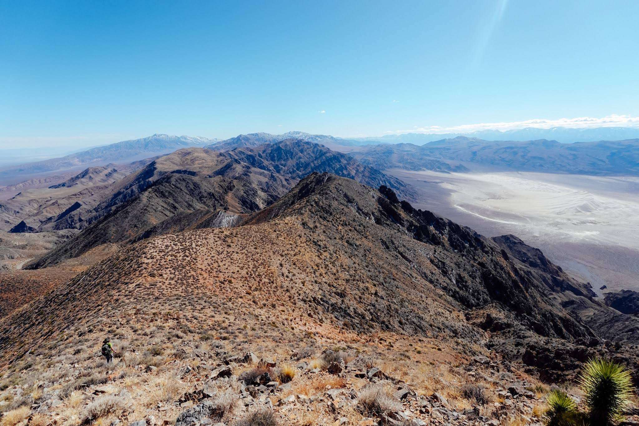
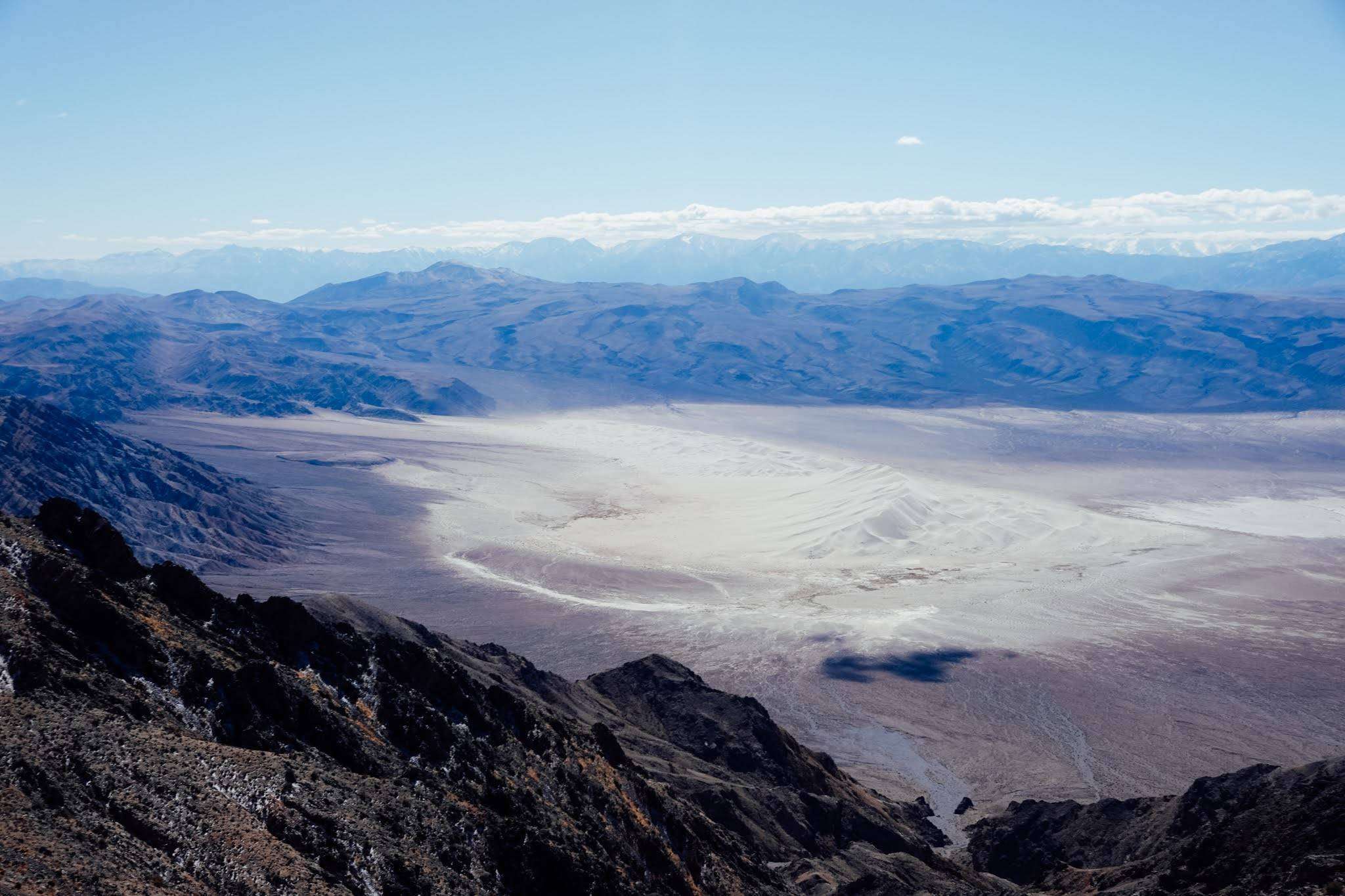
Once on the ridge, the going was smooth. We summited Sandy Benchmark, took a nice long break, and cracked on. The terrain from here became much more challenging and involved. Travel was slow, probably slower than one mile and hour. There were steep, loose descents, followed by steep, loose climbs, again and again. At one point we descended to a saddle that nearly touched the floor of Death Valley itself to our east! Crazy! Along this stretch of ridge our efforts were rewarded. To our west we could see the Eureka Dunes, Saline Range, Inyos, and Sierra Nevada all at once. It was truly breathtaking. And to our east and south we saw the Grapevines, Funerals, Blacks, and the desert ranges of Nevada all reaching out to infinity.
The sun was starting to set and the wind was beginning to kick up and so we tried to make steady progress towards a nice low plateau as the terrain eased. To protect ourselves from the wind overnight, we descended a wash for a hundred feet or so and set up camp on some slanted and rocky terrain. This was a tradeoff we were willing to take if it meant less wind while we slept.
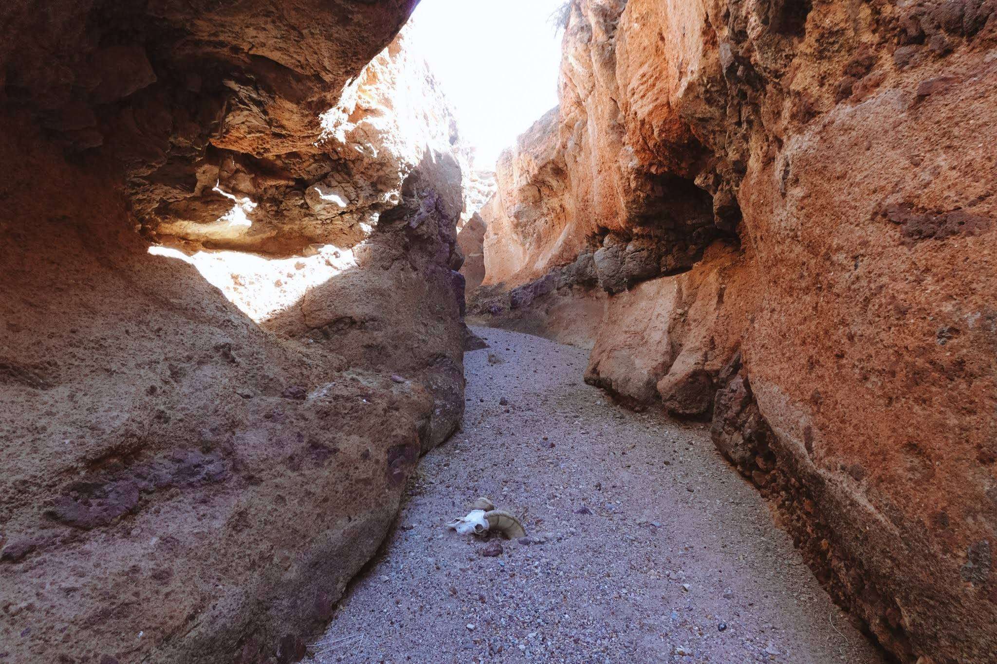
We both slept soundly, and the joke was on us because the wind died down as soon as we fell asleep. No matter, we were up and off in no time. It wasn’t more than a couple hours before the ridge mellowed out and we cut southwest to join the dirt road near Steel Pass. A beautiful unnamed and seldom traveled canyon took us down to the road. It had some impressively sheer walls, beautiful rock, and small dryfalls the whole way down. One would never guess that such a magnificent canyon lay ahead when looking up the unassuming wash leading to it from the road.
We road walked for six or so hours down from Steel Pass, past the stupendously tall Eureka Dunes, and up Eureka Valley back to our cars. I miscalculated the distance on my map and we were pleasantly surprised to see our cars a full hour before I was expecting to. A hearty dinner was cooked and we consumed it voraciously.
Anthony’s knee was feeling decent and so we decided to do another hike the next morning. This time we would be hiking up to the town of Crater again, but turning north to traverse the very northern reaches of the range.
We were up early, I think by 5 a.m. or so, and we shuttled a car up to Crater to save us a few miles. We intended to do this hike in a day and this move helped our cause. We walked through the disorienting ruins of Crater, exploring some scarily deep mines and other oddities along the way. Eventually, we started sending it up a ridge that looked like it would take us to the crest of the range.
Sure enough, it did, and we were soon traversing the very pleasant northern reaches of the Last Chance Range. This part of the range was full of beautiful Pinyon Pines and other spectacular flora. What an experience to experience the alpine zone in the world’s hottest and driest place. After many hours hiking and soaking in the views of the Inyos and the Sierra, we made it to Last Chance Mountain. We took a short snack break and cracked on.
At this point we began to more seriously discuss how we would descend off the crest to our north. Anthony had some ridge lines to the northwest in mind while I favored a ridge further to the east that seemed less precipitous. We had very little beta for this route, though it was not like we could amass much more, as we had never heard of anyone traversing this range, so we studied the terrain carefully as we walked. Adding to this suspense was the intensifying presence of snow on the north aspects of the range. It was never deeper than our ankles, and the snow melting in my socks had a pleasant cooling effect.
Our pace slowed as we carefully decided what route to take off the range. We settled on a series of ridges to the north east, yet remained vigilant as to not drop off to precipitously to the east. This turned out to be a prudent choice, and before long we hit the dirt road that parallels Willow Creek. Willow spring was but a muddy trickle at this point, and fortunately we didn’t need any water anyways.
All that was left was for us to walk along this road for ten or fifteen miles back to the car. Down in the valley it certainly was warmer, but never too hot. The main challenge is that even when it is cool, the sun beats down upon the desert traveller with savage force. The only respite you get is by curling up under a scraggly creosote bush to try to get some partial shade. This we did only once. Anthony and I had an extremely lively conversation for almost the entire walk back which made for easy traveling. Anthony and I have found in each other the ideal hiking partner. This is a very special gift that not many are fortunate enough to ever know. Our fitness is almost always equal. We know when to hike together and when to leave a couple hundred feet of space. We know when conversation is warranted or when we should be left to our own devices. Our discussions are always good natured and pleasant, even when we disagree. When one of our navigational intuitions errs, the other’s usually is correct. We try to remain positive even when lost, cold, drenched, tired, out of water, or otherwise screwed. We can get ourselves out of almost any jam that we got ourselves into. The list continues but I’ll spare the reader. Needless to say, I am grateful to have found Anthony. He is a good friend and a great hiking partner.
We made it back to the car, drove up to fetch the other, drove back down to Eureka Valley, and cooked some food. After gorging once again, Anthony left with the sunset as he had work the next morning. I would remain for a solo hike the next day. I leaned against the solitary wooden sign that marked the junction I was parked at and watched his car fade into the desert expanse. A deep peace that can only be known in the desert blanketed me as I beheld the magnificent Inyos, the Saline Range, the infinite Eureka Valley, and the Last Chance range we had just traversed.